THE FOLLOWING IS THE FINAL UPDATE FOR THIS BLOG:
Hurricane Harvey on Friday became the first Category 4 hurricane to make landfall in the United States since Hurricane Charley in 2004. Go here for the latest from KHOU, KVUE's sister station in Houston.
NOTE: This story will be updated throughout the weekend with new forecasts and information. TAP HERE for the latest forecast from the KVUE Storm Team.
Harvey lost a lot of its strength when it made landfall Friday, but has regained some strength since drifting back over the Gulf of Mexico. It made a second landfall near Cameron, La. on Wednesday morning, bringing heavy rain to the Beaumont/Orange/Port Arthur areas, as well as Port Charles, La.
Blog: Monday, Aug. 28
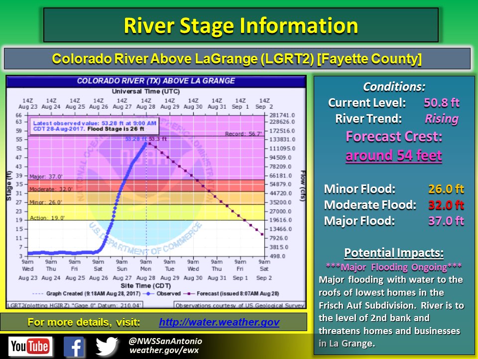
3:34 p.m. - The Colorado River at La Grange is now at 54.12 feet. Once this crest is determined to be official by the USGS it will be the third highest crest on record. The first highest came in at 56.70 feet in 1869 and the second highest came in at 56.40 feet in 1913.
1:15 p.m. - Colorado River at La Grange is currently at 54.03 feet, according to the National Weather Service. It could get as high as 55 feet soon. It's already the highest in over 100 years.
12:59 p.m. - KVUE's Christy Millweard is hearing that the National Guard is evacuating neighborhoods by the country club in La Grange.
10:45 a.m. - Highway 71 is closed in both directions due to flooding near La Grange. Avoid the area.
9:49 a.m. - The National Weather Service reports that the Colorado River at La Grange is now forecast to crest at around 54 feet, a few feet below a record set 104 years ago. KVUE's Erika Lopez said this is expected to happen later Monday morning. Go here for that story.

9:30 a.m. - Residents at two assisted living places in La Grange, Texas were evacuated early Monday morning as waters began to rise after this weekend's heavy rains. Go here for that story.
1:36 a.m. - ATXFloods reports 556 low-water crossings closed across Central Texas.
1:28 a.m. - Caldwell County Office of Emergency Management warns residents to not let their guards down, saying in part:
"Initial surveys show the road network suffered more damage than the Halloween Flood of 2013, Memorial Day Flood of 2015, All Saints Day Flood of 2015 and the June flood of 2016 COMBINED." (TAP HERE to read the full statement.)
12:50 a.m. Monday - New advisory for Harvey has it as a tropical storm, with maximum sustained winds of 40 mph. Torrential rain remains biggest threat from storm.
12:01 a.m. - TxDOT says both directions of Interstate 10 are closed at mile marker 655, which is near Waelder.
Sunday, Aug. 26
11:37 p.m. - NWS extends flash flood warning for Bastrop, Caldwell, Fayette and Lee Counties until 5:45 a.m. Monday.
9:46 p.m. - Bluebonnet Electric Cooperative says it is dealing with 41 outages affecting 846 members.
9:45 p.m. - NHC cancels Tropical Storm Warning for Caldwell County.
9:37 p.m. - NWS says it expects Colorado River to crest near Bastrop around 30.1 feet on Monday afternoon. Crest near Smithville expected late Monday/early Tuesday near 33.3 feet. Crest expected between Monday afternoon and Tuesday near La Grange at 51.3 feet.
8:24 p.m. - Bastrop County authorities post "Voluntary evacuations for residents on Kahana in Tahitian Village. The river is currently at 23.7 and if it rises near 26.7 residents would not have access out of the area for several days. Bastrop County Sheriff's Office is currently going door to door to notify residents."
7:50 p.m. - Williamson County swift water team has deployed in Houston, sheriff's office says.
7:30 p.m. - Multiple schools have delayed or canceled Monday classes. TAP HERE for the latest closures/delays.
5:43 p.m. - NWS extends Flash Flood Warning for Bastrop, Caldwell, Fayette and Lee Counties until 11:45 p.m.
5:35 p.m. – Gov. Greg Abbott expands the State Disaster Declaration to include Bastrop, Burleson, San Jacinto and Polk Counties. Fifty-four counties are now included in the State Disaster Declaration.
4:55 p.m. - NWS says a rainfall record has been set at Austin-Camp Mabry. 1.90 inches of rain has fallen at Mabry since 12 a.m. Sunday, breaking the old record of 1.72 inches set in 2001.
4:33 p.m. – NWS says the LCRA gauge on the Colorado River at Smithville has surpassed 20 inches of rain total from Harvey. The Colorado River is flowing at 56,945 cubic feet per second. That is enough to fill an Olympic-size swimming pool every 1.55 seconds! TAP HERE for rain gauge information from the LCRA Hydromet.
4:25 p.m. - Williamson County Sheriff Robert Chody says a boat team has departed to assist rescue efforts in Houston.
4:20 p.m. - Wind Advisory issued for Travis, Williamson and Lee Counties until 1 a.m. Monday. Wind Advisory issued for Bastrop, Comal, Fayette and Hays Counties until 1 a.m. Monday.
4:14 p.m. - Austin Energy says full power restoration "will take multiple days." TAP HERE for full release from Austin Energy.
4:12 p.m. - Bluebonnet Electric Cooperative says it is responding to 39 outage affecting 555 members.
3:49 p.m. – NHC cancels Tropical Storm Warning for Bastrop, Comal, Fayette and Hays Counties.
1:30 p.m. - Fayette County extends mandatory evacuation to areas along the Colorado River outside the incorporated area of La Grange. Officials said this is a life-threatening event with the river expected to crest Monday morning. Residents are being asked to leave the area no later than 3 p.m.Sunday and report to the shelter at Second Baptist Church, located at 1010 North Von Minden, La Grange. Officials said residents should expect to be away from their homes for at least 72 hours.
9:40 a.m. - Fayette County issues mandatory evacuation for area near La Grange Station
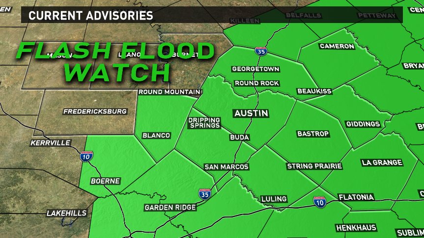
6:58 a.m. Flash Flood Watch remains in effect for parts of Central Texas until Wednesday evening.

6:47 a,.m. - Flash Flood Warning remains in effect for Bastrop, Caldwell, Fayette and Lee County until 11:45 a.m.

5:21 a.m. - KVUE's Jenni Lee reports mandatory evacuations on Highway 95 in Bastrop County.
3:51 a.m. - Harvey is still a tropical storm and now has maximum sustained winds of 45 mph.
3:26 a.m. - Gov. Greg Abbott has declared Caldwell County a disaster area. The declaration will be forwarded to FEMA for a Presidential Declaration. The process will include inspection of damaged areas in the coming weeks.
3:21 a.m. - There are four voluntary and mandatory evacuations in Bastrop County:Bastrop County:
- 2-mile lane from FM 153 to Highway 71 under voluntary evacuation
- 548 and 545 SH 95 north of Bastrop under mandatory evacuationBastrop under mandatory evacuation
- Ponderosa Road south of the 200 block under voluntary evacuation
- Crafts Praire Road from Mesa Pinto Drive to Ponderosa RoadPraire Road from Mesa Pinto Drive to Ponderosa Road
3:05 a.m. - At least 25 homes were flooded in Smithville as emergency crews continue to rescue people stuck in water, according to KVUE's news partners at the Austin American-Statesman.
2:04 a.m. - Austin Energy says it has more than 140 outages impacting 19,000 customers.
1:44 a.m. - NWS extends Wind Advisory for Travis, Williamson and Lee Counties until 1 p.m. Sunday. Sustained winds 25-35 mph and gusts up to 40 mph expected.
1:30 a.m. - NWS issues Flash Flood Warning for Travis and Hays Counties until 5 a.m. Sunday. Additional 3-6" rain possible in addition to rain that has already fallen over area.
1:17 a.m. - Bastrop police say they have issued four voluntary and mandatory evacuations due to flooding from Harvey. Full statement:
Bastrop County has received approximately 14”-16” of rain thus far from Hurricane Harvey. Due to the sheer volume of this water, numerous road closures have been conducted. All road closures have been reported to ATXfloods.com. A shelter has been opened at the Smithville Rec Center. Approximately 45 people have taken shelter at this location. At least four voluntary and mandatory evacuations have been ordered. Several water rescues have been conducted. No injuries have been reported. The Bastrop Emergency Operations Center, located at the Bastrop Police Department, is fully staffed and operating to coordinate all aspects of this event. The emergency operations center will conduct a news briefing at 10A at the Bastrop Police Department.
1:14 a.m. - Bastrop County reports additional water rescues in Smithville, including 100 block of Bunte and along Pecan Shores Drive.
1:09 a.m. - Bastrop County reports water rescue in progress along 1600 block of Woodress lane in Smithville.
1:01 a.m. - Pflugerville police reminds residents to NOT move barricades from closed roads. Weiss Lane still closed between Pflugerville Parkway and East Pecan.
12:53 a.m. - Austin police say traffic lights are out on Lamar between 18th and 38th Streets. Austin Energy working to repair more than 160 separate outages impacting more than 15,000 customers.TAP HERE for the Austin Energy outage map. (Other outage maps are linked lower in the story.)
12:51 a.m. - NHC releases 1 a.m. advisory for Tropical Storm Harvey says it "continues to produce extremely heavy rains" while slowly weakening.
12:21 a.m. - LCRA Hydromet site for Colorado River at Smithville has reported 15.10" rain in last 48 hours. TAP HERE for Hydromet site data.
12:15 a.m. - Emergency managers in Bastrop and Caldwell Counties advise some flood barriers have been blown down.
12:05 a.m. - Bastrop County "discouraging travel on all roadways due to extremely hazardous life-threatening conditions. Turn Around, Don't Drown."
Saturday, Aug. 26
11:55 p.m. - Eastbound lanes of Texas 71 closed at Smithville due to high water.
11:20 p.m. - Bastrop County Office of Emergency Management reports "multiple" water rescues in progress in the county.
11:10 p.m. - ATXFloods.com reports more than 330 low-water crossings are closed.
10:08 p.m. - A flood advisory has been issued for Hays and Travis Counties until 5 a.m. Sunday
10:00 p.m. - The City of San Marcos says it will open the San Marcos Activity Center at 501 E. Hopkins at 11:30 p.m. as a shelter for San Marcos residents who want to voluntarily leave flood-prone areas.
9:55 p.m. - Austin Energy is reporting more than 120 separate power outages across its coverage area. TAP HERE for the Austin Energy outage map. (Other outage maps are linked lower in the story.)
9:00 p.m. - Caldwell County authorities report two swiftwater rescues near Lytton Springs and north of Luling. TAP HERE for closed low-water crossings from ATXFloods.com
8:53 p.m. - FLASH FLOOD WARNING issued for Caldwell, Hays, Guadalupe, Bastrop, Lee and Fayette Counties until 4:45 a.m.
6:50 p.m. - National Hurricane Center says Tropical Storm Harvey now drifting east-northeast at 2 mph.
6:33 p.m. - Austin Fire Department closes ALL waterways in Austin until at least Aug. 31.
Effective immediately, the Fire Chief has closed ALL waterways in Austin until at least 8/31. Read more at https://t.co/faTsZ6L9Zd. pic.twitter.com/eojUiVNYtk
— Austin Fire Dept (@austinfiredept) August 26, 2017
6:05 p.m. - ABC News reports Gov. Greg Abbott activates more than 1,300 members of the Texas Army and Air National Guard, as well as Texas State Guard.
More than 1,300 members of Texas Army and Air National Guard, as well as Texas State Guard, activated for #Harvey. https://t.co/U5SGd0QpTz pic.twitter.com/TaQ8ajHMFW
— ABC News (@ABC) August 26, 2017
5:30 p.m. - Bastrop County Judge Paul Pape has declared a disaster in Bastrop County.
5:30 p.m. - Austin-Bergstrom has recorded 4.62 inches of rain since 12 a.m., breaking the old daily rainfall total for Aug. 26, which was 3.50 inches in 1947.
5:19 p.m. - Austin police report sinkhole near 7200 Circle S Road, which is near William Cannon and South Congress.
Traffic Hazard: Large sinkhole near 7200 Circle S Rd. Use caution and follow traffic cones to divert around the area. PIO11
— Austin Police Dept (@Austin_Police) August 26, 2017
3:38 p.m. - As Tropical Storm Harvey remains stationary over south Texas, large amounts of rain is expected across south, central, and east Texas.
1 p.m. - Hurricane Harvey was downgraded to a tropical storm with maximum sustained winds at 70 miles per hour.
12:10 p.m. - After a bit of a break, a band of strong winds and heavy rain is approaching Austin, Texas.
12 p.m. - National Guard arrives in Port Aransas to aid with Hurricane cleanup, KIII News Reporter Briana Whitney said.
9:30 a.m. - Radar estimates of over 10 inches of rainfall in northeastern Fayette County. KVUE Chief Meteorologist Albert Ramon says more rain is expected over the next few days.
9:20 a.m. - All Austin public libraries closing at 4 p.m.
9 a.m. - Austin Fire Department reports swamped intersection at Terry-O Lane and Industrial Boulevard in South Austin. AFD said they were able to get the driver out safely.
8:45 a.m. - The City of Austin Office of Homeland Security announced all Austin Parks and Recreation facilities would close at 4 p.m. due to deteriorating weather conditions.
7:45 a.m. - A tornado warning for Bastrop and Lee counties was canceled.

7 a.m. - A tornado warning was issued for Bastrop and Lee counties.
1:54 a.m. - A Tornado Watch has been issued for Fayette and Lee Counties until 1 p.m. Saturday.
Power outages
Agencies are reporting multiple power outages across Central Texas.
TAP HERE for the Oncor outage map.
TAP HERE for the Austin Energy outage map.
TAP HERE for the PEC outage map.
TAP HERE for the Bluebonnet Electric Cooperative outage map.
Traffic
These pages continually update as conditions change across the Austin area and across Texas.
TAP HERE for closed low-water crossings from ATX Floods.
TAP HERE for the latest traffic conditions in Austin.
TAP HERE for road conditions across Texas from TxDOT.
TAP HERE to view flight status at ABIA.
What you can do to prepare for severe weather
The Capitol Area Council of Governments (CAPCOG) has a system people can register for, that will send emergency alerts by text, email of phone. TAP HERE for more information and to sign up.
The Texas Department of State Health Services has free disaster preparedness guide that everyone can use. TAP HERE for more information.
The state also has an emergency site that people can follow. As of Tuesday, the state is not tracking any emergencies, but the site has useful information with which people can prepare. TAP HERE for more information.
DPS has a list of sites on their site that people can use to prepare for any potential storm impacts. TAP HERE for more information.
The National Hurricane Center has its preparedness guide online as well.
The Central Texas Red Cross is already recommending residents download the Red Cross Emergency App in case the storm does make landfall in Texas.
What first responders are doing to prepare
The Austin Fire Department has an 18-member crew ready to help people affected by Harvey.
Thursday afternoon they were getting their supplies, trucks and boats ready.
Eight members will be serving on Texas Task Force 1, a federal team under the FEMA Urban Search and Rescue System. This group will be assisting with land rescues. Four members are helicopter search and rescue technicians who will do air rescues if needed and the remaining six members are on the boat squad for water rescues. One will be stationed in Corpus Christi and seven will be stationed in Austin until they're needed.
"They'll be deployed along the I-35 corridor bouncing from location to location depending on where the storm ends up," said Division Chief Palmer Buck. "We know that the weather reports say it's going to strike near Corpus Christi but after that nobody knows where it's going to go and so we'll be chasing the storm."


