AUSTIN, Texas — For the first time in several weeks, we've had an improvement on the drought monitor!
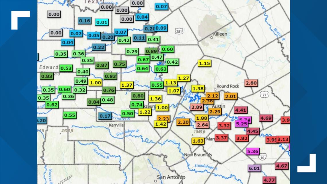
Last week's storm system brought heavy rainfall to many areas, mainly east of Interstate 35. Some of the heaviest amounts were recorded in Bastrop County, where multiple Lower Colorado River Authority (LCRA) gauges got close to 6 inches. Additionally, an LCRA gauge at Lake Bastrop has received nearly 7 inches over the past month.
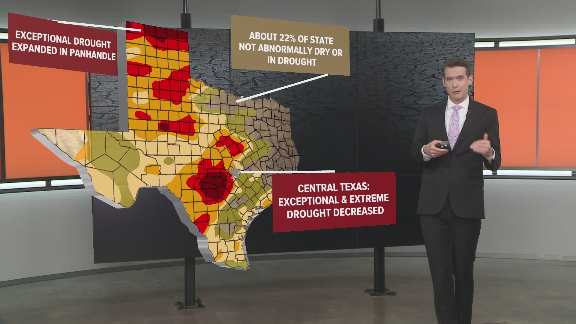
As a result, we've seen improvements to the drought monitor. However, in order to truly estimate how much of an improvement, it's important to note last week's drought monitor.
Last week's heavy rainfall did not take place in time for it to be recorded on that week's monitor. Instead, it was recorded on this week's monitor, which was released Thursday.

Last week's drought monitor shows that most areas southwest of Austin were still in an "exceptional" drought, including areas like Wimberley, Jacob's Well and Dripping Springs in Hays County. Additionally, many areas in the Coastal Plains were in a "moderate" level of drought, and portions of Fayette County – which had the most radar-estimated rainfall – were even in a "severe" level of drought.
However, in this week's drought monitor, we see vast improvements east of I-35 – where the heaviest rain fell – and we even see some improvement in Hays County, which is no longer in that exceptional drought category. It has been downgraded to an extreme level of drought.
That means there is still a ways to go, but it is possible that with the upcoming forecasted El Niño, we should see further improvements in the drought.
The largest improvements took place in the Coastal Plains, where areas of Fayette County that were under severe level of drought are now only "abnormally dry," meaning they are barely in a drought at all.
In fact, portions of Milam and Lee counties are no longer classified as being in a drought as a result of last week's rain.
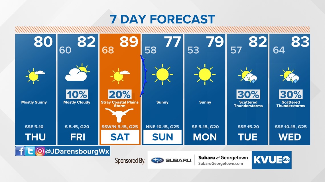
As for what's to come, while we may only see slight rain chances on Friday for our northern counties, there is a slight chance of a stray storm in the Coastal Plains on Saturday as a cool front slides in. The next true widespread rain chance would come on Wednesday, but models are currently not in agreement at this time.
Stick with KVUE for the latest on your forecast!
In the meantime, here is an extended look at your forecast: