

AUSTIN, Texas — Our coolest air so far of the season is officially here. To be completely honest, we know that's a pretty low bar, but Wednesday's high temperature of 68 in Austin was the coolest since back in March!
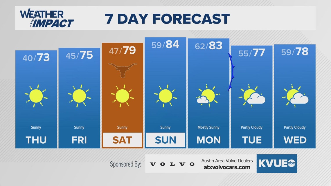
Now the stage is set for our coldest night so far of the season with widespread mid to upper 30s expected across our KVUE area by Thursday morning. For most, this will not be the first official freeze of the season, but there could be a brief light freeze for some of the absolute coldest wind protected valleys in the Hill Country. Otherwise, with a calm wind we expect many areas to get some light frost early Thursday morning including parts of the Austin metro. Tonight's the night to bring in any sensitive outdoor plants!
The afternoon for Thursday will be fantastic with sunshine and high temperatures back in the low to mid 70s. The weather stays the same for Friday with a cold morning, but very pleasant afternoon.
High temperatures will return to the 80s for Sunday into the start of next week. However, a week cold front could drop us back into the 70s for the middle of next week and Thanksgiving Day.
WEDNESDAY NIGHT:
Clear and cold. Patchy frost possible. Calm wind.
LOW: 40
THURSDAY:
Sunny and pleasant. Southwest wind at 5 mph.
HIGH: 73
THURSDAY NIGHT:
Clear and chilly. Light west wind.
LOW: 45
SEVEN-DAY FORECAST:

Check out the live radar for what you can expect the rest of the day and into the workweek.