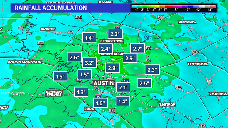
AUSTIN, Texas — The heaviest rain has now moved out of Central Texas, and all Flash Flood Warnings have been allowed to expire. With that being said, we're not completely done with the rain just yet.
Lingering scattered showers and storms will remain possible through Saturday evening and the early overnight. We are not expecting this activity to be as widespread or as heavy as the main event earlier today, but additional rain could add to any existing flooding.
We've had numerous reports of closed roads and flooded low water crossings today, so please continue to be very mindful if you must travel tonight. Remember to never drive through any flooded roadways. Turn around, don't drown.
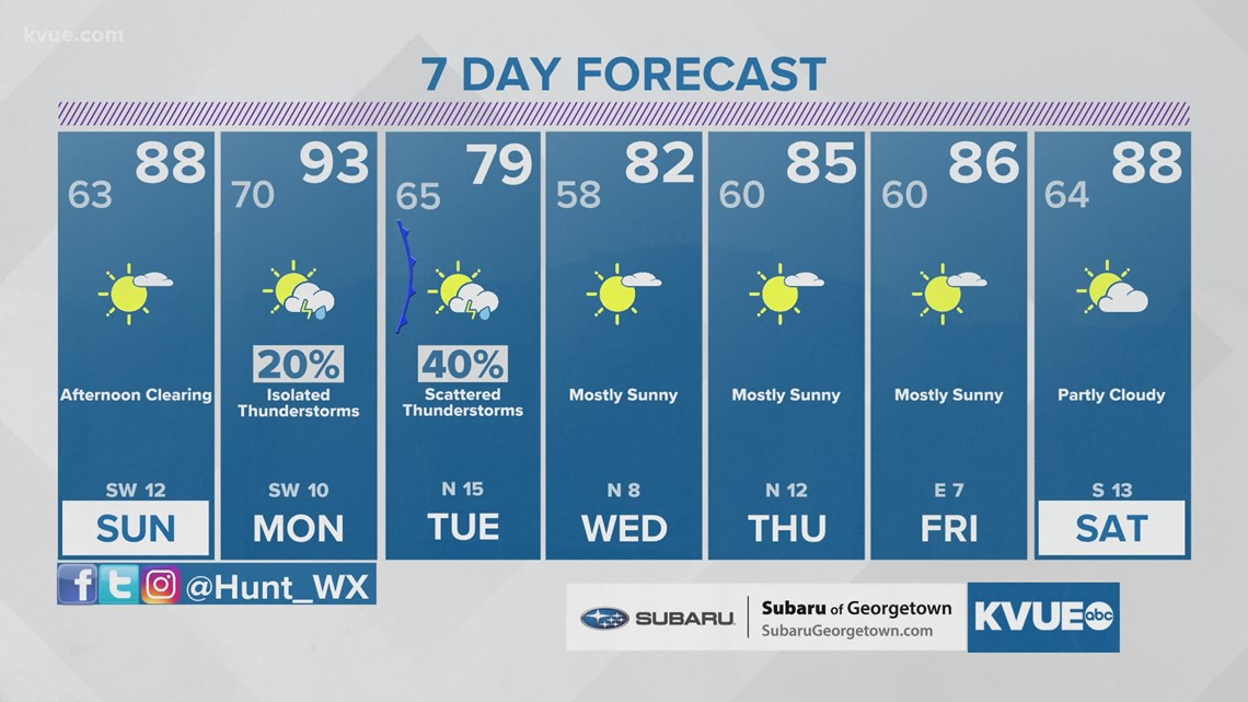
So the worst of the rain has ended, but we're still keeping an eye out for any additional rain from lingering showers and storms through tonight. The weather should be dry by Sunday morning, and Sunday afternoon will be warm and mostly sunny.
Be sure to download KVUE's app to check radar and get updates on stormy weather: kvue.com/app. Also be sure to follow KVUE on Facebook, YouTube, Twitter and Instagram.
Drivers are encouraged to stay off the roads while the storms are in the area, and several low-water crossings are closed as of Saturday afternoon. Check road conditions in your area at atxfloods.com.
Here are the latest updates:
7:15 p.m. – A Flash Flood Warning for parts of Williamson County has expired.
6:20 p.m. – A Flood Advisory has been issued for parts of Gillespie County until 9:15 p.m. as a strong storm moves in with heavy rain and lightning.
6 p.m. – A Flash Flood Warning for parts of Travis and Bastrop counties including Austin, Pflugerville, Bastrop, Manor and Elgin has expired.
5:45 p.m. – Heavy rain is pushing northeast, but scattered showers remain on Saturday evening. Showers and storms continue to move in across the Hill Country.
5:30 p.m. – The National weather service has allowed the Flash Flood Warning for Hays and Caldwell counties to expire.
4:40 p.m. – KVUE Chief Meteorologist Erika Lopez is providing a live update on the storms. Watch below or on the KVUE YouTube channel:
4:20 p.m. – The Lower Colorado River Authority says floodgate operations are underway at Lake Bastrop Dam. One floodgate is partially open. Flows downstream of Lake Bastrop Dam on Spicer Creek and Piney Creek will be higher and faster than usual.
4:15 p.m. – A Flash Flood Warning has been issued until 7:15 p.m. for Williamson County including Round Rock, Cedar Park and Georgetown.
3:45 p.m. – A Flood Advisory has been issued for Williamson County and parts of Lee County until 6:45 p.m.
3:40 p.m. – KVUE's Mike Marut took the video below on Macmora Road in North Austin. He said the nearby creek is the highest he's ever seen it.
3 p.m. – A Flash Flood Warning has been issued until 6 p.m. for parts of Travis and Bastrop counties including Austin, Pflugerville, Bastrop, Manor and Elgin.
2:50 p.m. – Motorists are advised to stay off the roads as heavy rain moves across the Central Texas region.
2:34 p.m. – The road is closed at Old Bastrop Highway at Cottonwood Creek, according to the Hays County Office of Emergency Services.
2:32 p.m. – A Flash Flood Warning has been issued for an area including San Marcos, Kyle and Lockhart until 5:30 p.m.
The heaviest rain has come to an end for Central Texas, but we still have the possibility of some scattered rain and storms through the rest of this evening. All Flash Flood Warnings have now been allowed to expire.
We've had numerous reports of closed roads and flooded low water crossings today, so please continue to be very mindful if you must travel tonight. Remember to never drive through any flooded roadways. Turn around, don't drown.
By Sunday morning all rain should be gone, and the afternoon on Sunday will be warm and mostly sunny with highs in the 80s. Temperatures will soar into the 90s by Monday afternoon with a slight chance for a few storms during the late afternoon and evening.
Our next cold front will move through on Tuesday with scattered showers and storms, and then seasonable and pleasant weather filters in for the rest of the work week.
Be sure to download KVUE's app to check radar and get updates on stormy weather: kvue.com/app. Also be sure to follow KVUE on Facebook, YouTube, Twitter and Instagram.
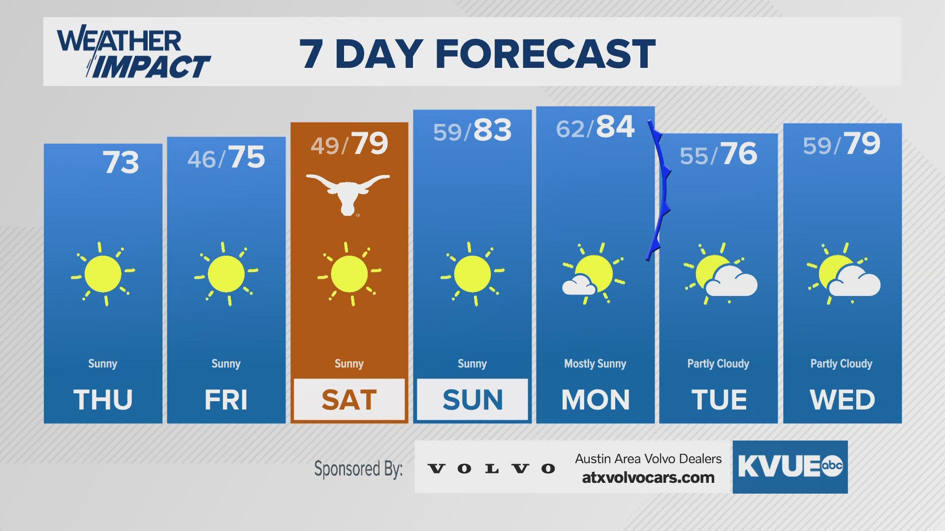
In the meantime, the extended forecast can be found below:


