AUSTIN, Texas — Editor's note: This live blog is no longer being updated.
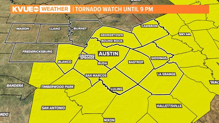
A Flash Flood Watch is currently in effect for much of Central Texas through Thursday afternoon. A Tornado Watch is also in effect until 9 p.m.
Here are the latest updates from Tuesday, May 18:
10:15 p.m. - A Flash Flood Warning is in effect for areas including Flatonia until 12:15 a.m.
8 p.m. - Counties along the Interstate 35 corridor, including Travis, Williamson and Hays counties, have been dropped from the Tornado Watch. Additional counties may be dropped before the watch expires at 9 p.m., the National Weather Service said.
7:53 p.m. - A Flash Flood Warning including La Grange, Schulenburg and Halletsville is in effect until 11:15 p.m.
7:45 p.m. - The Tornado Warning in Fayette County has expired. Threats for flash flooding remain.
Around 997 Fayette Electric Cooperative customers are without power.
7:33 p.m. - A live look in Flatonia from the Fayette County Sheriff's Office.
The sheriff's office also confirmed water rescues were underway.
7:14 p.m. - La Grange and Rutersville are now included in a Tornado Warning until 7:45 p.m.
7:05 p.m. - Radar indicates the tornado reported near La Grange is nearly stationary at this time.
6:59 p.m. - Citizens near Swiss Alp in Fayette County and Halletsville are urged to take shelter.
6:48 p.m. - A tornado has been confirmed on the ground near Swiss Alp in Fayette County.
6:45 p.m. - Tornado Warning extended to La Grange and Swiss Alp until 7:15 p.m. A ground confirmation has also been reported in Schulenburg.
A Flash Flood Warning has been issued in Gonzales, Shiner and Flatonia until 10:15 p.m.
6:40 p.m. - Tornado Warning including Hallettsville, Shiner and Breslau until 7:30 p.m.
6:28 p.m. - Fayette County is included in a Tornado Warning until 7 p.m.
6:22 p.m. - A Tornado Warning has been issued for the Flatonia and Schulenburg areas until 6:45 p.m.
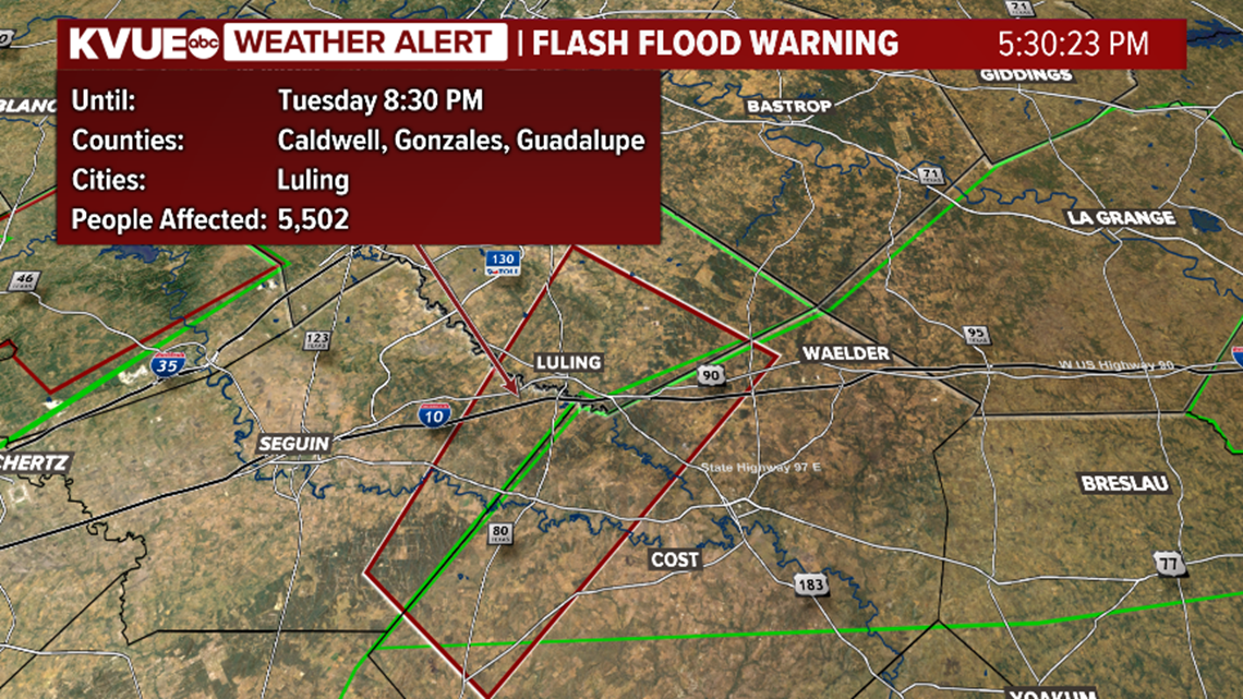
5:20 p.m. - A Flash Flood Warning for Caldwell, Gonzales, and Guadalupe counties is in effect until 8:30 p.m.

4:30 p.m. – A Severe Thunderstorm Warning for Bastrop, Caldwell, Travis, Fayette and Lee counties is in effect until 5:30 p.m.
4:25 p.m. – A Severe Thunderstorm Warning for Caldwell County is in effect until 5:30 p.m.
3:45 p.m. – A Severe Thunderstorm Warning has been issued for Hays, Caldwell, Travis and Comal counties until 4:45 p.m.
3:35 p.m. – A Severe Thunderstorm Warning has been issued for Comal, Caldwell, and Guadalupe counties until 4:30 p.m.
2:55 p.m. – A Severe Thunderstorm Warning has been issued for parts of Hays County, including the Wimberley area, until 3:45 p.m. Hail up to nickel size and 60 mph winds are possible.
2:30 p.m. – A Tornado Watch has been issued for much of Central Texas, including Blanco, Williamson, Travis, Hays, Milam, Lee, Fayette, Bastrop and Caldwell counties, until 9 p.m.
2 p.m. – A Severe Thunderstorm Warning is in effect for Blanco, Bexar, Comal and Kendall counties until 2:45 p.m. The storms moving in bring the potential of 60 mph gusts and quarter size hail.
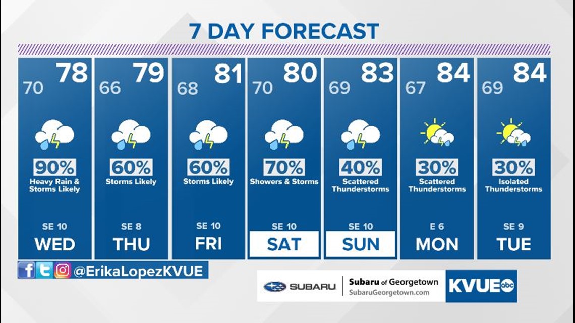
Outlook for Tuesday/Wednesday
A rainy and stormy week continues in Central Texas. This will include daily rain chances and the possibility of severe weather and flooding. We're expecting the stormiest of the weather around Tuesday and Wednesday.
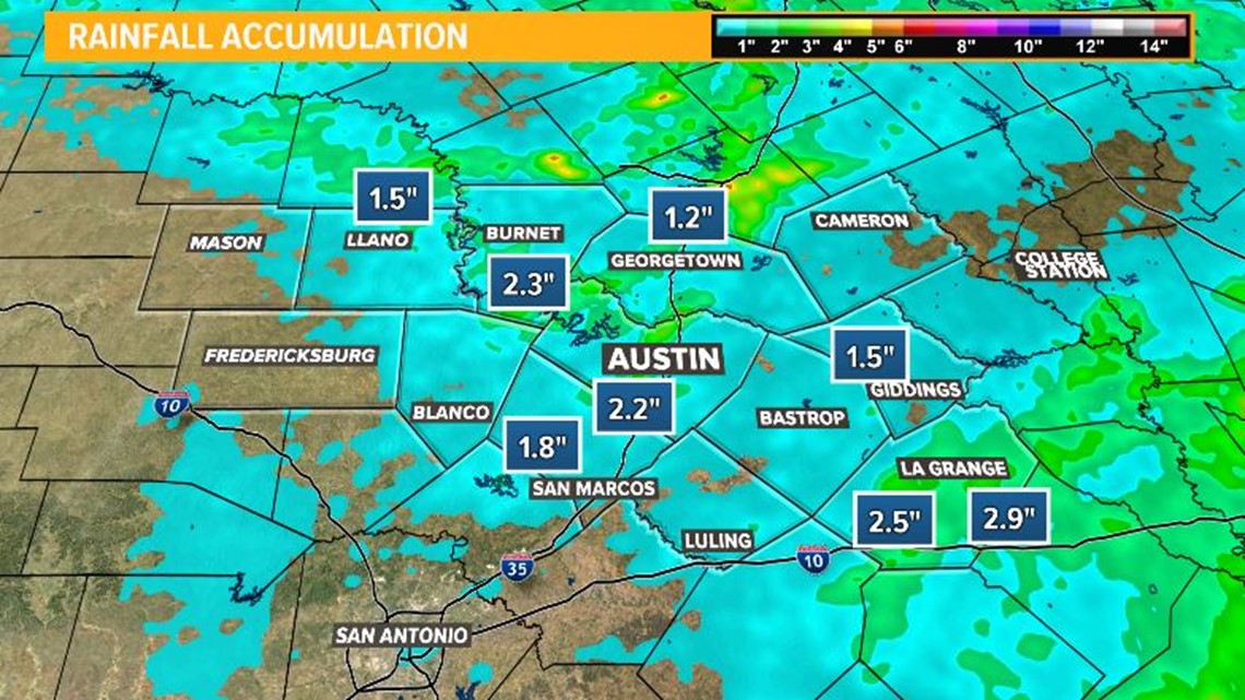
Monday brought a strong round of showers and storms, which dropped one inch to three inches of rain across Central Texas. Parts of the Hill Country remained completely dry.
Download the KVUE app to check radar, to get updates and to upload pictures and video: kvue.com/app. Also be sure to follow KVUE on Facebook, Twitter, YouTube and Instagram.

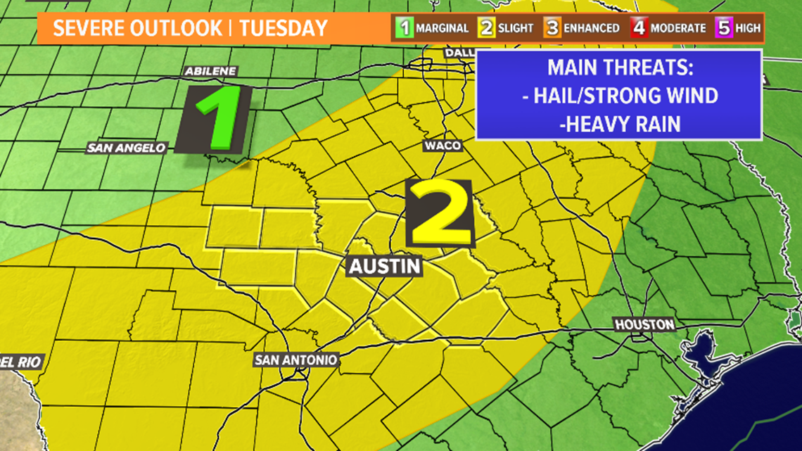
Tuesday brings another round of severe weather potential. Most of Central Texas is under a "slight" risk – level two out of five – for severe weather.

We're still on track to see the most widespread rain and storms on Tuesday and Wednesday. The exact timing of multiple rounds of storms will come into focus in the coming days, but this will include the risk not just for severe storms but also for flooding.

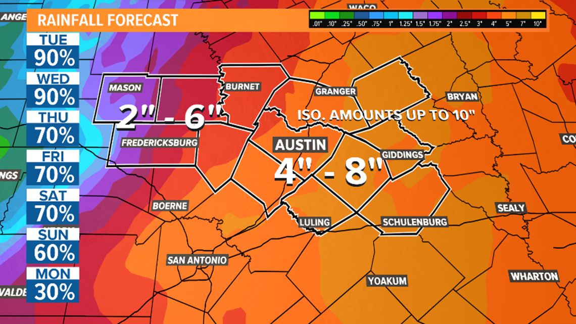
We're expecting a fairly widespread two to eight inches of rainfall over the next seven days, with most of that coming on Tuesday and Wednesday. Isolated amounts as high as 10 inches will be possible, especially along and east of Interstate 35.
Although a bit drier, we will keep at least scattered rain and storms in the forecast through the weekend.

The KVUE Storm Team will continue to monitor this developing forecast.
In the meantime, the extended forecast can be found below:
For the latest updates and push alerts on severe weather, download the KVUE app.